Early Map of New England
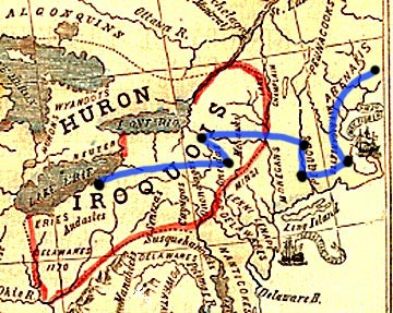 |
This map shows the location of indian groups in North America about 1770. Note the location of the Abenakis just north of the eastern most location (Casco Bay). The movement of James Harper descendants is shown in blue. The Iroquois nation is circled in red. This map will take several seconds to load, (81K) however an enlarged view should reload quickly on request. Clicking on the image will bring up a larger view. |
||
 |