The following is
the driving itinerary for the NY leg
and does not include our plans for the evening
meals.
Directions Distance
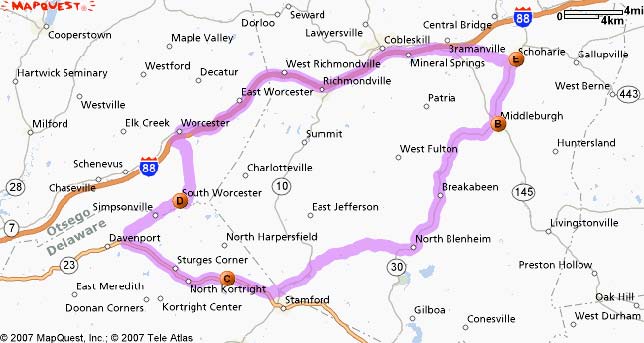
![]() 1: Start out going SOUTH on MAIN ST/NY-30 toward JOHNSON AVE. Continue to follow NY-30. 4.9 miles
1: Start out going SOUTH on MAIN ST/NY-30 toward JOHNSON AVE. Continue to follow NY-30. 4.9 miles
![]() 2: Turn LEFT onto DANFORTH AVE. 0.1 miles
2: Turn LEFT onto DANFORTH AVE. 0.1 miles
![]() 3: Turn RIGHT onto SHELDON ST. <0.1 miles
3: Turn RIGHT onto SHELDON ST. <0.1 miles
![]() 4: Turn RIGHT onto RAILROAD AVE. <0.1 miles
4: Turn RIGHT onto RAILROAD AVE. <0.1 miles
Estimated Time: 9 minutes Distance: 5.17 miles
![]() 1: Start out going SOUTHWEST on RAILROAD AVE toward MAIN ST/NY-145. <0.1 miles
1: Start out going SOUTHWEST on RAILROAD AVE toward MAIN ST/NY-145. <0.1 miles
![]() 2: Turn RIGHT onto MAIN ST/NY-145. Continue to follow NY-145. 0.2 miles
2: Turn RIGHT onto MAIN ST/NY-145. Continue to follow NY-145. 0.2 miles
![]() 3: Stay STRAIGHT to go onto NY-30. 13.2 miles
3: Stay STRAIGHT to go onto NY-30. 13.2 miles
![]() 4: Turn SLIGHT RIGHT onto NORTH RD/CR-2. 2.2 miles
4: Turn SLIGHT RIGHT onto NORTH RD/CR-2. 2.2 miles
![]() 5: Turn LEFT onto BLENHEIM HILL RD/CR-12. 4.4 miles
5: Turn LEFT onto BLENHEIM HILL RD/CR-12. 4.4 miles
![]() 6: Turn SLIGHT LEFT onto NY-10. 2.7 miles
6: Turn SLIGHT LEFT onto NY-10. 2.7 miles
![]() 7: Turn RIGHT onto TERRY RD. 1.0 miles
7: Turn RIGHT onto TERRY RD. 1.0 miles
![]() 8: Turn SLIGHT RIGHT onto NY-23. 2.5 miles
8: Turn SLIGHT RIGHT onto NY-23. 2.5 miles
![]() 9: Turn RIGHT onto WILCOX RD. 0.1 miles
9: Turn RIGHT onto WILCOX RD. 0.1 miles
![]() 10: Turn LEFT onto COL HARPER DR. <0.1 miles
10: Turn LEFT onto COL HARPER DR. <0.1 miles
Estimated Time: 34 minutes Distance: 26.75 miles
![]() 1: Start out going WEST on COL HARPER DR toward NY-23. 0.4 miles
1: Start out going WEST on COL HARPER DR toward NY-23. 0.4 miles
![]() 2: Turn SLIGHT RIGHT onto NY-23. 7.4 miles
2: Turn SLIGHT RIGHT onto NY-23. 7.4 miles
![]() 3: Turn RIGHT onto CR-9/BUTTS CORNERS-OTSEGO CO LINE RD. 3.3 miles
3: Turn RIGHT onto CR-9/BUTTS CORNERS-OTSEGO CO LINE RD. 3.3 miles
![]() 4: CR-9/BUTTS CORNERS-OTSEGO CO LINE RD becomes CR-40. 1.7 miles
4: CR-9/BUTTS CORNERS-OTSEGO CO LINE RD becomes CR-40. 1.7 miles
Estimated Time: 16 minutes Distance: 12.93 miles
![]() 1: Start out going EAST on CR-40 toward CR-39. 0.3 miles
1: Start out going EAST on CR-40 toward CR-39. 0.3 miles
![]() 2: Turn LEFT onto CR-39. 6.0 miles
2: Turn LEFT onto CR-39. 6.0 miles
![]() 3: Turn RIGHT onto MAIN ST/NY-7. 1.0 miles
3: Turn RIGHT onto MAIN ST/NY-7. 1.0 miles
![]() 4: Turn RIGHT onto HOLLENBECK RD. 0.3 miles
4: Turn RIGHT onto HOLLENBECK RD. 0.3 miles
![]() 5: Merge onto I-88 E via the ramp on the LEFT. 18.3 miles
5: Merge onto I-88 E via the ramp on the LEFT. 18.3 miles
![]() 6: Take the RT-145 exit- EXIT 22- toward RT-7/COBLESKILL/MIDDLEBURG. 0.3 miles
6: Take the RT-145 exit- EXIT 22- toward RT-7/COBLESKILL/MIDDLEBURG. 0.3 miles
![]() 7: Turn RIGHT onto NY-145. 1.5 miles
7: Turn RIGHT onto NY-145. 1.5 miles
![]() 8: Turn LEFT onto SCHOHARIE HILL RD/CR-1A. Continue to follow CR-1A. 4.2 miles
8: Turn LEFT onto SCHOHARIE HILL RD/CR-1A. Continue to follow CR-1A. 4.2 miles
![]() 9: Turn LEFT onto MAIN ST/NY-30. 0.4 miles
9: Turn LEFT onto MAIN ST/NY-30. 0.4 miles
Estimated Time: 38 minutes Distance: 32.76 miles
Total Estimated Time: 1 hour, 37 minutes Distance: 77.61 miles
Old Stone Fort at Schoharie - Fee $5.00 adults, $4.50 Seniors, $1.50 children 5-17 Tour museum ULR:http://www.schohariehistory.net/OSF.htm Library - see Harpersfield Land Records Brant-Harper Letters Probable time 2 hours
Middleburgh, NY Site of Middle Fort used by Col. John Harper and Alexander as base of operations during Revolution. Battle of the Flockey in which Col. Harper played a significant role. Probable time 10 minutes
Harpersfield, NY Trip takes you up old indian trail between the Middle Fort and Harpersfield. Several signs note trail location. Harpersfield Rural Cemetery (Stevens Cemetery) Thomas and James Hendry burials both killed in Sugar Bush Massacre April 8th, 1780 under command of Captain Alexander Harper URL: http://www.dcnyhistory.org/cem_harpersfield_rural.html Harpersfield Cemetery location of graves of Col. John Harper and many other Harper family members including Hotchkiss, Gaylord and others. URL: http://www.dcnyhistory.org/cemharpersfield.html Location of Col. John's home and first mill on west side of the cemetery. Col. Harper Grange (possible location for lunch/dinner) Shaver-Hill Farm (Harpersfield hosts) Former dairy farm now Maple Sugar operation. URL: http://www.shaverhillfarm.com/ Probable time 4-5 hours
Possible side trips in around Harpersfield: Revolutionary battle locations including approximate location of Capt. Alexander's capture and McKee cabin massacre. Abigail Harper Chapter of the D.A.R. in Stamford, NY
Directions Distance
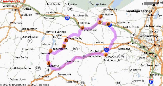
1: Start out going NORTH on MAIN ST/NY-30 toward PROSPECT ST/CR-18. Continue to follow 2.5 miles NY-30.
2: Turn SLIGHT RIGHT to stay on NY-30. 9.6 miles
3: Turn RIGHT to stay on NY-30. 6.6 miles
4: Turn SLIGHT LEFT onto FORT HUNTER RD/CR-145. 4.8 miles
5: Turn LEFT onto NY-5S. 0.1 miles
6: Turn SLIGHT RIGHT onto MAIN ST/CR-27. 0.4 miles
7: Turn LEFT to stay on MAIN ST/CR-27. 0.2 miles
8: Turn RIGHT to stay on MAIN ST/CR-27. 0.1 miles
9: Turn LEFT onto CHURCH ST. <0.1 miles
Estimated Time: 33 minutes Distance: 24.62 miles
1: Start out going SOUTHWEST on CHURCH ST toward QUACKENBUSH ST. <0.1 miles
2: Turn RIGHT onto QUACKENBUSH ST. 0.1 miles
3: QUACKENBUSH ST becomes MAIN ST/CR-27. 0.5 miles
4: Turn LEFT onto MOHAWK DR/CR-26. 2.8 miles
5: Turn LEFT onto NY-5. 2.1 miles
6: End At Fonda, NY
Estimated Time: 10 minutes Distance: 5.74 miles
1: Start out going WEST on W MAIN ST/NY-30A/NY-5 toward BROADWAY. <0.1 miles
2: Turn RIGHT onto BROADWAY/NY-30A. Continue to follow NY-30A N. 4.5 miles
3: Turn LEFT onto E STATE ST/NY-67. 0.5 miles
4: End At Johnstown, NY
Estimated Time: 8 minutes Distance: 5.09 miles
1: Start out going SOUTHEAST on E STATE ST/NY-67 toward UNION PL. 0.5 miles
2: Turn RIGHT onto S COMRIE AVE/NY-30A S/MAYOR HARVEY W MANSFIELD HWY. Continue 4.0 miles to follow NY-30A S.
3: Turn SLIGHT RIGHT onto WEMPLE AVE/CR-32. Continue to follow WEMPLE AVE. 0.1 miles
4: Turn LEFT onto CAYADUTTA ST/NY-334. 0.1 miles
5: Turn RIGHT onto W MAIN ST/NY-5. Continue to follow NY-5. 11.4 miles
6: Turn LEFT onto CHURCH ST/NY-10. 0.3 miles
Estimated Time: 23 minutes Distance: 16.75 miles
1: Start out going SOUTH on CHURCH ST/NY-10/ROCK ST toward MOHAWK ST. Continue to 6.4 miles follow NY-10.
3: Stay STRAIGHT to go onto NY-163. 1.3 miles
4: Turn SLIGHT LEFT onto VANDEUSENVILLE RD/CR-81. 1.2 miles
5: Turn LEFT onto CR-32. 2.5 miles
6: Stay STRAIGHT to go onto NY-166. 2.1 miles
7: Turn SHARP LEFT onto LANCASTER ST/CR-50. <0.1 miles
Estimated Time: 24 minutes Distance: 16.16 miles
1: Start out going NORTHWEST on LANCASTER ST/CR-50 toward MAIN ST/NY-166/CR-54. <0.1 miles
2: Turn LEFT onto NY-166/ALDEN ST. Continue to follow NY-166. 4.0 miles
3: End At Roseboom, NY
Estimated Time: 6 minutes Distance: 4.14 miles
1: Start out going SOUTHWEST on NY-166 toward ROSCO JONES RD. 6.9 miles
2: Turn RIGHT onto CR-52. 2.9 miles
3: Turn SLIGHT RIGHT onto CR-33. 0.2 miles
4: Stay STRAIGHT to go onto ESTLI AVE. 0.6 miles
5: Turn LEFT onto MAIN ST/CR-31. 0.3 miles
Estimated Time: 17 minutes Distance: 11.15 miles
1: Start out going WEST on MAIN ST/CR-31 toward PIONEER ALY. 0.1 miles
2: Turn LEFT onto CHESTNUT ST/NY-80. Continue to follow CHESTNUT ST. 0.8 miles
3: CHESTNUT ST becomes NY-28. 7.7 miles
4: Turn RIGHT onto W MAIN ST/CR-44. <0.1 miles
5: End At Milford, NY
Estimated Time: 14 minutes Distance: 8.71 miles
1: Start out going EAST on W MAIN ST/CR-44 toward NY-28/S MAIN ST. Continue to follow W 0.6 miles MAIN ST.
2: W MAIN ST becomes NY-166. 0.3 miles
3: Turn RIGHT onto CR-35B. 0.2 miles
4: Turn RIGHT onto CR-35. 0.9 miles
5: Turn LEFT onto KONCHAR RD. 1.7 miles
6: KONCHAR RD becomes CRUMHORN LAKE RD. 1.5 miles
7: Turn RIGHT onto CR-42. 0.6 miles
8: Turn LEFT onto NY-7. 2.2 miles
9: Turn SLIGHT RIGHT onto CHASEVILLE RD SPUR. 0.1 miles
10: Turn SLIGHT RIGHT onto CR-56. 2.1 miles
11: Merge onto I-88 E via the ramp on the LEFT. 24.3 miles
12: Take the RT-145 exit- EXIT 22- toward RT-7/COBLESKILL/MIDDLEBURG. 0.3 miles
13: Turn RIGHT onto NY-145. 1.5 miles
14: Turn LEFT onto SCHOHARIE HILL RD/CR-1A. Continue to follow CR-1A. 4.2 miles
15: Turn LEFT onto MAIN ST/NY-30. 0.4 miles
Estimated Time: 52 minutes Distance: 41.60 miles
Total Estimated Time: 3 hours, 8 minutes Distance: 133.97 miles
Fort Hunter, NY Location of William Harper home during and after the American Revolution- Queen Anne Parsonage (privately owned by New York City family) State sign shows information. Probable time 10 minutes
Fonda William Johnson residence 1749-1762 (Old Fort Johnson) on the Mohawk east of Fonda. http://www.oldfortjohnson.org/ Montgomery County Dept. of History & Archives
Genealogy research for time period between Tryon County and Delaware
County formation Location: Dept. of History & Archives, back of Old Court House, Fonda, NY Time: ?
Johnstown Sir William Johnson Home 1762-1770 Johnson Hall - 1 hr. Fee: $3.00 adults, $2.00 NYS senior citizens, $1.00 children 5-12. URL: http://www.oldfortjohnson.org/jhallfolder/jhall.html Location: From Fonda, Left on Rte. 5, Right on 30A North to Johnstown, Left on East Main St., Right on N. William St., Right on Hall Ave. Location of signing for permission to purchase 250,000 acres of land from the Indians under the name of King George II of England.
Cherry Valley Cherry Valley Historical Museum - Fee: $5.00 adults, $4.50 Seniors, group of 10 or more $3.00, free under 11 years. Probable time at museum: 30 min. - 1 hour URL:http://www.cherryvalleymuseum.org/ Location of Rev. Samuel Dunlap's home Cherry Valley Cemetery (Mass grave marker) Wells House
Roseboom Location of Harper homestead (1755-1770/3) Probable time: 5-10 minutes
Cooperstown Research Library at New York State Historical Association - There is a $5/day library use fee.
Milford Location of Culley's and place of death of William Harper (exact location unknown) Probable time: pass through on way back from Cooperstown
South Worcester area Approximate location of Bartholomew cabin, point out direction and approx. distance from I-88 on the way back to Schoharie Probable time: pass by on way back to Schoharie
 BACK
BACK